Saturday, 13 December 2014

RIGHT-HAND & LEFT-HAND TRAFFIC

I assume that most of us have driven a car, or vehicle should I say, and some of us may have even started driving illegally (i.e. without an official license). Well, in this post, I am not going to touch on that subject, I am going to focus more on traffic flow. Traffic jam may sound like an interesting topic (I think), but I'm sure that many people have known about the implications and the causes of those incidences. Instead, I am going to talk about right-hand and left-hand traffic.

So, what do those two terminologies mean?

To put in rough, technical terms, it means that which side of the road do people drive in a specific country. Take a look at the following examples:

Image source: Link

The picture above is an example of a left-hand traffic. As you can see, the cars on the left side of the road are driving upward. You can even tell the same when you look in the opposite direction.

Image source: Link

The picture above is an example of a right-hand traffic. As you can tell, the cars on the right side of the road are driving upward. Pretty obvious isn't it?

The country that I live in, Malaysia, is one of the few countries that uses left-hand traffic.
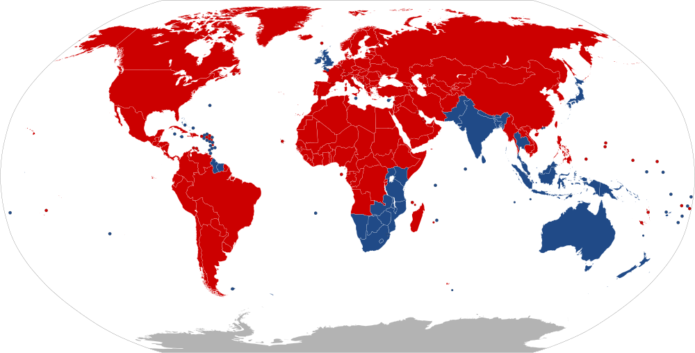
Image source: Link

The map above illustrates the countries that apply a certain kind of traffic flow. The countries in red use right-hand driving, whereas the countries in blue use left-hand driving. Visually, a majority of the world use right-hand driving. I was in awe when I saw this diagram for the first time.

Strangely enough, a majority of those blue countries belong to the Commonwealth of Nations. So could it be that when the British colonized these areas, they wanted to use left-hand driving so that they could be labelled as "one-of-a-kind"? I am going to let you reflect on that.

Now comes the part where I wanted to portray about the most in this post. Some of us have been to other countries by car. Example, if I were to enter from Malaysia to Singapore, I have to pass through an immigration border of each country. Once the process is done, it is back to on the road as usual. But thankfully, both Malaysia and Singapore drive on the left side. But have you ever wondered what actually happens when we have to change from a left-hand road to a right-hand road at the border?

I actually reflected on this question for years, but thanks to Internet and research, the mystery that was buried in my train of thought has finally uncovered.

There are 4 known ways to switch traffic from one side to another.

1. Using traffic lights


Image source: Link
This is the Second Thai-Lao Friendship Bridge. This picture is taken in Thailand where the bridge is heading to Laos. As you can see, the traffic lights play a role of controlling the traffic change so that no accidents or collisions occur. Well, how do they work?

Taken in Google Earth.
Thailand is on the left, Laos is on the right.

Let's zoom in a little.

See that little intersection there? That's how the traffic is controlled.

2. Crossover bridges

Image source: Link
This is the Lotus Bridge that connects Macau and mainland China. This is pretty much self-explanatory. Another example:

Taken from Google Earth.
Brazil is on the left, Guyana is on the right.
This is the Takutu River Bridge that connects Guyana and Brazil. Like the Second Thai-Lao Friendship Bridge, the roads intersect. But if you take a closer look, a road overlaps the other, so no collisions can occur.

3. Intersecting Roads

I couldn't find the images for this or Google Earth wasn't much help to, but the areas are Man Kam To that links China and Hong Kong, and Portas do Cerco that links China and Macau. Basically, these places use roundabouts or other one-way traffic system.

4. Signposts and directions only

These areas are commonly found in places where there are low traffic volumes.
Examples include:

Image source: Link
Poipet, Cambodia-Thailand


Image source: Link
Sino-Nepal Friendship Bridge, Nepal-China


Image source: Link
Moyale, Kenya-Ethiopia

Remember, always drive safe, and always keep your eyes on the road (or eye if you're a cyclops).

Article by,
DARELL NONIS

Friday, 17 October 2014

LANDLOCKED COUNTRIES

As we all know, planet Earth is covered with about 75% water. This means we only populate about 25% of the planet. Most countries have a lot of advantages in terms of coastal regions. They contribute to tourist attractions, fisheries, resources, and many more, that helps the country to increase economical development. However, there are some countries that do not have this advantage. Yes, and I am stressing that countries that do not border seas. Imagine what would be like to live in a country where you can't enjoy the beaches and you have to cross an immigration border to another country to do just that. That seems like a harsh challenge to fulfill just a simple task, but that's what life is for some people, and they seem to not complain about it.

Image source: Link
As seen in the image above, the highlighted countries are landlocked. As you can see, they don't border any oceans or seas or don't have any coastlines. As of today, there are currently 44 landlocked countries, 48 if you count the partially recognized countries. These countries have been cut off direct access to seaborne trade which apparently is one of the largest international trade. The only way to get them is to ask other countries to import the products into their country, which is often a burden due to tax and service consumption.

The 48 countries, by region, are:

SOUTH AMERICA
- Bolivia
- Paraguay

EUROPE
- Andorra
- Austria
- Belarus
- Czech Republic
- Hungary
- Kosovo*
- Liechtenstein
- Luxembourg
- Macedonia, FYR
- Moldova
- San Marino
- Serbia
- Slovakia
- Switzerland
- Transnistria*
- Vatican City

AFRICA
- Botswana

- Burkina Faso
- Burundi
- Central African Republic
- Chad
- Ethiopia
- Lesotho
- Malawi
- Mali
- Niger
- Rwanda
- South Sudan
- Swaziland
- Uganda
- Zambia
- Zimbabwe

ASIA

- Afghanistan
- Armenia
- Azerbaijan
- Bhutan
- Kazakhstan
- Kyrgyzstan
- Laos
- Mongolia
- Nagorno-Karabakh*
- Nepal
- South Ossetia*
- Tajikistan
- Turkmenistan
- Uzbekistan

*Partially recognized countries

Some interesting facts


  1. The newest addition to landlocked countries is South Sudan, the newest country in the world gaining independence in 2011.
  2. The largest landlocked country is Kazakhstan, and the smallest landlocked country is Vatican City.

Kazakhstan, Uzbekistan, Azerbaijan and Turkmenistan borders the saltwater Caspian and Aral Sea, but they are still landlocked countries because they do not have a coastline or border a sea region even though the two saltwater bodies are called 'Seas', they are technically somewhat a 'lake' surrounded by land.

3 of the countries are surrounded completely by only one country. This term is called 'enclave'. Vatican City and San Marino are enclaves of Italy, whereas Lesotho is an enclave of South Africa, making it the largest enclave in the world by area.

Locations of San Marino and Vatican City,
with the size of Lesotho in comparison.

Image source: Link

Location of Lesotho
Image source: Link

In fact, the misery of no coast lines doesn't end there. 2 of the landlocked countries are surrounded by other landlocked countries. These countries are called 'doubly-landlocked countries'. That's right, to get to the closest coastline, people have to go through 2 borders to get there. That is misery level 9000. And they are Liechtenstein and Uzbekistan.

The location of Liechtenstein
(labelled as LIECH.)

Image source: Link

As seen in the image above, Liechtenstein is surrounded by two landlocked countries of Switzerland and Austria. But putting it's area in perspective and where its location is, we can safely say and logically accept the fact that Liechtenstein is a doubly-landlocked country.

Location of Uzbekistan
Image source: Link
Uzbekistan, on the other hand, is the mother of doubly-landlocked countries, where it is surrounded by 5 landlocked countries of Kazakhstan, Kyrgyzstan, Tajikistan, Afghanistan and Turkmenistan. Despite being about 2800 times larger than Liechtenstein, it even baffles me to thinking a country quite large can be a doubly-landlocked country. This also officially makes Uzbekistan the largest doubly-landlocked country.

So to sum this up, even though you live way inland from the coast (like people living in Nebraska, Kansas or Missouri), please be thankful. You probably don't have a clue about the lives of people living in landlocked countries.

Article by,
DARELL NONIS